Early Angelina County
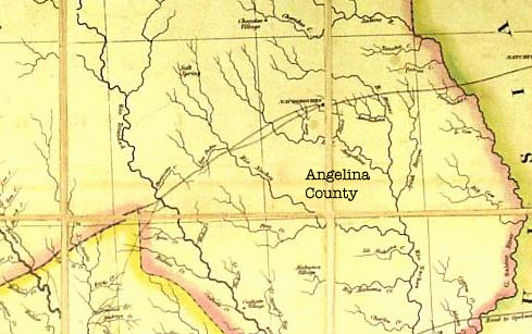
Burke is located in southwestern Angelina County, which was formed in 1846 from the southern part of Nacogdoches County. Angelina County lies between the northwesterly flowing Neches and Angelina Rivers, which provided the first easy commercial access to the county via steamboats as well as the first way to transport the county's timber resources to market.
Angelina County is shown below in Stephen F. Austin's map of 1830 as an entirely blank area between the Angelina River and Rio Neches devoid of even streams ("Angelina County" notation added). Clearly there was not much of note there at the time.
East Texas (Stephen F. Austin 1830)
The Kisatchie Wold
The geograpy of Angelina County is shaped by a geological feature known as the Kisatchie Wold, which is a ridge that stretches from the Mississippi flood plain to the Rio Grande Valley. It is the edge of a layer of hard limestone that reaches the surface and has resisted erosion to a greater degree than the sourrounding land. It is located just south of Angelina County passing through Tyler, Polk, and Trinity Counties and entering Angelina County at the far southeast end. The flooded rock quarry known as "Blue Hole" is in the Kisatchie Wold. The ridge rises gradually from the Gulf of Mexico an drops off precipitously on the northern edge and reaches heights of 400 to 450 feet above sea level in Tyler County.
The Kisatchie Wold was a barrier to the flow of streams toward the Gulf of Mexico, which caused the Neches River to flow more westerly than other rivers in East Texas. It also provided a natural highway through Lousisiana and East Texas for Indian trails and later roads for white emigrants from the South.
The ridge was considered a formidable obstacle to travel at one time. The Neches River crosses the Kisatchie Wold west of Rockland, and this provided an easy place for early roads to cross. Both the Alabama and Coushatta Traces, both Indian trails, follow the Kisachie Wold through the area, and prior to the Mexican Revolution Anglo settlers used the Indian trails to sneak into Texas. As a result the Spaniards built Fort Teran to prevent illegal entry by the immigrants. The crossing was also used by the Liberty-Nacogdoches Road, which was the primary road between East Texas and the Gulf of Mexico at the time.
The intersection of the Indian trails with the Neches River provided one of the primary points of entry into early Angelina County. As a result the early Anglo population center of the County was in the south end near present day Zavalla. The author's 3rd great grandfather James Parker and 2nd great grandfather Amos Spears originally settled in that area before moving to Lufkin after the railroad was built.
The Hasinai
Early visitors to what later became Angelina County found Indians of the Hasinai tribe inhabiting the Angelina and Neches River valleys. The Hasinai were a branch of the Caddos who inhabited almost the entirety of East Texas and who gave Texas its name from their greeting of "tejas", meaning "friend". Archaelogical investigations show that the Caddos were well established in East Texas by 800 A. D., but the first European encounters by Hernando De Soto did not occur until 1542. The remnants of the Hasinai who did not succumb to European diseases continued to live in their traditional homeland in the Angelina and Neches River valleys through the 1830s. By the early 1840s all Caddo groups had moved to the Brazos River in north Texas to escape the pressure from white settlers moving into East Texas..
Both the Angelina River and Angelina County are named for a Hasinai maiden who helped the early French missionaries and was affectionately know as "the little angel". Angelina County is the only county in Texas named for a woman. Springs such as those near Ryan Chapel Church undoubtedly attracted Native Americans as they did the later white settlers.
Indians from the East
The Caddos were replaced by tribes migrating from the Midwest (Shawnee) and Alabama and Mississippi (Mucogee, Alabama, Coushatta, Biloxi), who were trying to escape from white encroachments in the eastern states. A group of the Shawnee resided for a time in the area known as Shawnee Prairie northeast of Lufkin. The latter groups tended to settle south of Angelina County but some groups lived as far north as the Neches River in Tyler, Polk, and Trinity Counties. A group of Alabama lived in Trinity County on Alabama Creek, a tributary of the Neches lying just outside southwest Angelina County which was named for them. The later white settlement of Alabama Creek was not far from Pine Valley and some families moved back and forth between the two communities.Although there are no known official Indian sites in the Burke area, the author has heard rumors of arrowhead finds in northeast Burke north of the Angelina Couny Airport. There is also a "tanning vat" in the area that some believe is of Indian origins.
Arrival of Anglo Americans
The first known Anglo-American settlers in Angelina County were the Burris family, perhaps a forebear of the Burrous family of Burke. They settled in 1820 at Burris Prairie, which is located in the northern part of what is now the City of Lufkin.
The first Anglo-American in the Burke area was Tom Bradley, who arrived in 1835 from San Augustine to build a trading post on what came to be known as Bradley Prairie to trade with Indians residing along the Neches River. In the late 1840s cattle raising families such as the Ashworths arrived at Pine Valley several miles southwest of Burke.
Sources:
- Stephen F. Austin, 1830 Map of Texas
- Bob Bowman, TexasEscapes.com, "Fort Teran"
- Donald Burrous, Personal Recollections
- Handbook of Texas Online, "Alabama, Texas"
- Handbook of Texas Online, "Alabama-Coushatta Indians"
- Handbook of Texas Online, "Angelina County"
- Handbook of Texas Online, "Burris Prairie, TX"
- Handbook of Texas Online, "Caddo Indians"
- Handbook of Texas Online, "Hasinai Indians"
- Handbook of Texas Online, "Kisathcie Wold"
- Handbook of Texas Online, "Liberty-Nacogdoches Road"
- Handbook of Texas Online, "Shawnee Indians"
- Malcom McLean, Papers Concerning Robertson's Colony In Texas, Volume VIII, pages 192-195
- www.angelfire.com/tx/TCGS/trace1.html, "Alabama Trace"
- www.angelfire.com/tx/TCGS/trace1.html, "Coushatta Trace"